Fishing Our Habitat Work: Garvin Brook
Fishing & Restoring a SE MN Gem
Author: Mark Reisetter
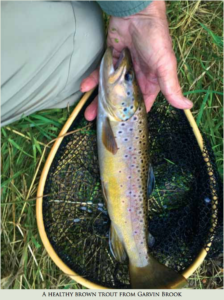
 Garvin Brook has long been an extremely productive brook and brown trout fishery, far exceeding what might be expected, given its small size, high visibility, easy road- side angling access, and proximity to the population center of Winona. After heavy rains, it becomes an even more valuable resource, as it is one of the first streams to clear up for quality fly fishing!
Garvin Brook gets its name from H. C. Garvin, a Winona our magnate who, along with his wife, Louise, donated a sizable tract of land to Winona County in 1925 near the headwaters of this beautiful spring creek. With that newly acquired parcel, Winona County created “Farmers Park,” the entrance of which is located near the twin stone arches, circa 1882, which carry the railroad over Winona County Road 120 and Peterson Creek, a small tributary of Garvin Brook. Farmers Park remains a much-used picnicking and family gathering location to this day. The August 2007 flood ravaged this valley, almost totally destroying Farmers Park, ripping up the corridor. On its way to join Rollingstone Creek and the Mississippi River, over ten miles downstream, it flooded Stockton and much of Minnesota City.
The Trout Unlimited Habitat Improvement Project, originally slated for 2012, finally began in June of 2014. Previously, the section of Garvin Brook that runs through Farmers Park had been worked on by the MNDNR in 2008, led by Brian Nerbonne, the current MNDNR Stream Habitat Consultant.
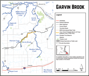
The Win-Cres Chapter of TU selected the 6,355-foot (1.2 mile) stretch of Garvin Brook that runs along U.S. High- way 14, between the high railroad trestle at the upstream end and the railroad bridge on the downstream end, partially because of the high public exposure this work would receive. In the MNDNR Fisheries “Trout Angling” map booklet, this work is shown on Map 8, on pages 20-21. There, you will also see that the entire improved reach is a special regulations stretch that is restricted to artificial lures or flies only, and has a protected slot for all trout 12” to 16”.
This portion of Garvin Brook became braided in several areas after the 2007 flood. Channels of the stream, with previous HI work from 25 years ago, were abandoned. Five large pools, the biggest being 540’ long and 50’ wide, were created by the flood; the pools reduced ow and created shallow water, which tended to warm the stream in the summer, and freeze it in the winter. Garvin Brook also had some highly erodible, vertical mud banks that had to be sloped. The flood, in exposing so much bare rock and soil, also created opportunities for invasive plants, such as garlic mustard and the hardy Japanese knotweed, to flourish and out-compete the natives in the disturbed ground.
A challenge in the design process was the fact that the riparian corridor is un- usually tight because of the manmade “dikes” on both sides of the stream, namely the highway and railroad beds. The project’s onsite work was a solid collaboration between the MNDNR Fisheries Habitat Crew from Lanesboro, specifically Fisheries Specialist Steve Erickson and his main equipment operators, Rex Bearbower and Blake Lee, and Win-Cres TU. In addition to the stream work, the fisheries crew also constructed two snake hibernacula (one made from rocks, the other from logs), and two depressions adjacent to the stream for frogs and turtles.
 An angler’s parking lot off of Highway 14 was constructed about halfway in the project reach on state forest land, at TU’s suggestion. Dave Svien, before he retired as MNDNR Forester in the Lewiston office, prepared the necessary paperwork for MNDOT. When approval was granted, the Lanesboro Fisheries crew constructed the lot and access ramp, several years before the actual project began.
TU also installed a water quality monitoring station before the project began, just below the mid-point as the stream comes close to the highway. In addition to measuring air temperatures and rainfall amounts, the monitor also measures dissolved oxygen, stream temperature, and helps determine the stage–discharge relationship for the stream.
My preferred method to sh the stretch is to park in the angler’s parking lot, walk down to the lower end, and begin fishing back upstream. The walk down to the lower end (on the Wachholz property) is worth it because a couple of the holes at the lower end are often quite generous.
When you get back upstream, directly opposite the parking lot, perhaps the deepest hole abuts the railroad, and its embedded skyhooks are placed about 5 to 6-feet below the surface. I usually fish two or three bends above that point, and then return to the truck. I drive up to Winona County Road 120 and park by the double gates next to the stream. From there, I walk down- stream as far as I think my remaining time allows, and fish back up. Some anglers fish up from the parking lot and then walk back down the highway, but, really the “roads” that were built to deliver the rock to the stream are still discernible and provide solid footing in a fairly direct line, which allows one to avoid walking a busy thoroughfare.
As Win-Cres used eight of the leftover skyhooks from the Pine Creek project, there are some bank hide structures, along with some “cribs” that were also installed. Don’t overlook the areas where the grasses provide some overhang, as well. Some great depth along this stretch was also created, so be careful not to go over your chest waders in a few of the deeper holes. In truth, much of this stretch can be fished from the banks.
Bank stabilization was ensured in numerous spots by implanting root wads, which right now can make fishing difficult in a few locations. On the flip side, those areas will grow some fish. Over time, these obstructions will be worn down and become less noticeable. A friend of mine had a 16 inch trout wrap his tippet around a submerged root and it never came to net, but the memory of the encounter lingers comfortably.
Garvin Brook has always had great caddis hatches, and throughout the summer, the magical evening hour before dusk can really be amazing. Since the habitat work, the terrestrial action has been greatly improved because of the openness and the grasses. Late summer into the fall brings phenomenal grasshopper fishing.
The fishing in Garvin Brook is good, and it’s only going to get better because of the great collaboration of MN DNR Fisheries and Forestry, MN TU, Win-Cres TU, TU DARE, TU National,WSU, the Winona County SWCD and Federal Farm dollars, the Stockton-Rollingstone-Minnesota City Watershed District, MNDOT, the LSOHC, our MN legislature, and most importantly, the important landowners. This project is ongoing, as funds to support work on the next stretch from the railroad bridge downstream have been approved. The project on Garvin Brook should continue through the Oevering property, as it meanders its way toward Stockton along scenic U.S. Highway 14.